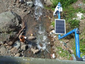
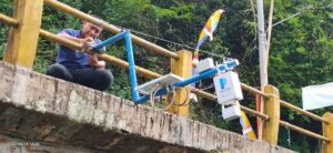
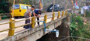
A certain amount of rainfall can cause flooding, so a monitoring tool is needed to predict this amount. In line with the Strategic Plan of the Universitas Indonesia Community Service Program 2020-2024, one of which is to develop and disseminate science and technology to answer the challenges of problems in the community. The team from the Department of Geosciences, Faculty of Mathematics and Natural Sciences, Universitas Indonesia, led by Dr. Eng. Supriyanto, was present directly in the Citengah River area, South Sumedang District, to install rainfall monitoring technology, on Thursday (18/8/2022). This technology by the nation’s children is named pantir. Dr. Eng. Supriyanto said that pantir has the ability to measure rainfall intensity, river water level, ground water level, temperature and environmental humidity in the installation area. “Pantir can be relied upon to mitigate flood disasters through monitoring river water level, groundwater level and rainfall intensity in the catchment area,” said Supriyanto, explaining the use of pantir. The measurement results can also be accessed by the public through the website at https://dev-pantir.geosinyal.id by filling in the email address: public@geosinyal.id and password: public.
Under normal conditions, the Pantir tool’s measurement results will be updated every 10 minutes. However, under standby conditions, the measurement results are updated every 5 minutes or even every 3 minutes. Pantir was designed and developed in the Disaster Laboratory of the Department of Geosciences FMNS UI in 2019.
Pantir began testing in real environments throughout 2020, namely in the UI campus area and Depok City. Entering 2021 to 2022 pantirs have also been installed in three rivers in West Java, namely the Ciliwung river in Depok City, the Cibeet river in Karawang Regency, and the last and most recent one was in the Citengah river in Sumedang Regency.
Embedded in this technology is a digital electronics 32-bit microcontroller that controls the water level monitoring sensor and rainfall intensity sensor. Pantir monitoring data can be stored on an SD-Card or sent to a database server via the internet.
Monitoring by the pantir is done inreal time. “Another advantage of Pantir is the GPS receiver feature so that the monitoring time (year, month, day, hour, minute, second) is synchronized with the server and other Pantir stations,” said the Head of the Disaster Laboratory of the Department of Geosciences Faculty of Mathematics and Natural Sciences.
Another advantage, said Supriyanto, is that the solar power source that powers Pantir makes it independence from State-run Electricity Company so that Pantir can be placed in remote areas.
With a maximum power consumption of 15 Watts, the pantir battery can last up to 3 days without supply from the sun. The head of Citengah Village in South Sumedang, Drs. H. Otong Sumarna, M.Pd., welcomed the installation of the pantir to monitor the water level of Citengah River. According to him, Citengah Village has experienced flash floods due to river overflow in the past 2 years. Meanwhile, the Head of BPBD Sumedang Regency, Drs. Atang Sutarno, M.Si., who also accompanied the installation of the Pantir tool also expressed his gratitude to the Universitas Indonesia Faculty of Mathematics and Natural SCience team for choosing Sumedang, especially Citengah Village, as a partner area for the trial location.
With the installation of the pantir, Atang hopes that the Sumedang Regency BPBD can optimize the monitoring of the movement of the Citengah river water level, and other potential disasters throughout the Sumedang District Area.