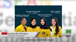
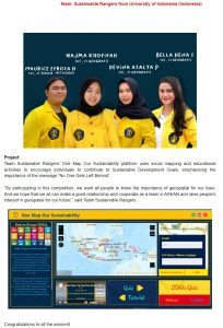
Victory! Four Universitas Indonesia (UI) students participating in a team styled the Sustainable Rangers, namely Maurice Efroza (Engineering ’19), Bella Hena Samira (Maths & Natural Sciences ’19), Najma Khofifah (Maths & Natural Sciences ’19), and Devina Azalya (Maths & Natural Sciences ’19), won a medal in the ASEAN Geospatial Challenge 2022. Sustainable Rangers is represents Indonesia in this international competition after having in 2021 achieved the title of National Champion in the Indonesian Geospatial Challenge 2021.
This time, Sustainable Rangers proposed a project they call “One Map, Our Sustainability”. This project makes use of a social mapping platform which allows anyone to contribute in the fulfillment of one or more of the UN’s Sustainable Development Goals (SDGs) through ArcGis, an open-source software. One Map, Our Sustainability places an emphasis of an inclusive and equitable principle of aforesaid SDGs: no one left behind. With this theme, Sustainable Rangers UI managed to secure a Merit Award (equivalent to a Bronze Medal).
ASEAN Geospatial Challenge is a challenge that promotes the usage of technology and geospatial information in encouraging Southeast Asian states in their bid to fulfill the SDGs set by the UN. Twenty-six other teams from five countries participated in this competition alongside Universitas Indonesia.
“Efforts to attain SDG targets are a priority of national development that requires synergy of policy-planning at national and provincial levels as well as that of the regency and city. Geographic Information Systems, or GIS for short, possesses a unique feature when compared to other basic systems of data management: it allows [one] to present spatial and non-spatial [forms of] information in tandem,” stated Maurice, who, along with Bella Hena Samira, acts as a SDGs Student Ambassador from Universitas Indonesia.
“SIG allows us to perform spatial analysis in order to map potentials in Indonesian territory. SIG facilitates the user in making decisions pertaining to spatial aspects. It is hoped that, with the aid of GIS to map territories, the government and people of Indonesia may map the potential of each territory, and detect potentials that may be utilised in territories inside Indonesia. This study may support efforts towards equitable development efforts in order to fulfill various aspects of the Sustainable Development Goals, and to include the participation of society in contribution [towards the goals],” stated Bella.
The dean of the Faculty of Technology, Prof. Dr. Heri Hermansyah, ST., M.Eng, IPU, explained that achievements in the ASEAN Geospatial Challenge are “active contribution on the part of students to promote and encourage the implementation of the UN’s Sustainable Development Goals. May the UN’s SDGs become a norm [accepted] in social life, not merely becoming goals and aims.”
Meanwhile, the dean of the Faculty of Mathematics and Natural Scienes, Dede Djuhana, Ph.D., stated, “We appreciate the victory of a team from UI and encourage other students from UI to keep creating innovations according to their respective field of studies. It is hoped that this breakthrough, achieved by a team from UI, may be [further] developed and used as a reference or ‘database‘ by universities as well as the central government, regional governments, and related institutions in applying the ideal policies that may deal with various issues and problems in their respective areas of jurisdiction.”